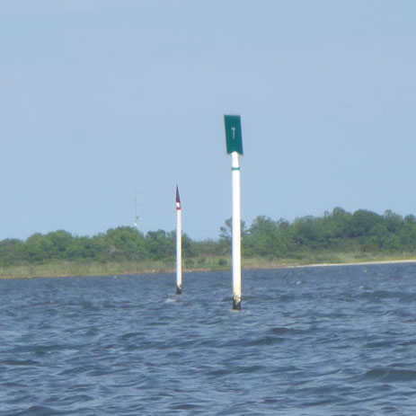
 In this age of cable, Netflix, and Hulu, with 100s of channels to choose from there is one channel you want to avoid – the boat channel! This time of year there are lots of boaters on the water. We are lucky at Coastal Kayak because Little Assawoman Bay is much shallower and smaller than both Assawoman Bay (behind Ocean City) and Rehoboth Bay. This means a lot less boat traffic. The shallow water also means one other thing, and that is that most motor boaters in our bay will stay in the boat channel.
The channel is a narrow lane through the bay that typically has deeper water. The important thing for us as paddlers is that we want to avoid the channels when possible. But if we have to cross them, we want to minimize our time in them.
Before you can avoid a channel, you must be able to determine where it is. In Little Assawoman it begins at the Rt.54 bridge and runs mostly north, with a few curves, ending at the Assawoman Canal entrance at the north end or our bay. Channels are marked by buoys or, in our case, daymarks. These are poles with green and red signs on top. The signs on top of the poles are either green squares with odd numbers on them, or red triangles with even numbers on them. In low visibility you might make out the shape but not the color. But if it is a triangle, you know it is red.
The first rule motor boaters are taught is the phrase “red-right-return.” This means that if you are returning from the ocean (or larger body of water), to stay in the channel, you will keep the red markers on your right and the green ones on your left. The problem arises when you don’t know whether you are coming or going. (Jen says that’s often the case with me.) For example, in Little Assawoman Bay if you head south you will eventually reach the ocean through the Ocean City Inlet. And if you head north, you will eventually get to the ocean through the Indian River Inlet. So in which direction are we “returning?”
This is where the numbers on the markers comes in. The numbering starts with the marker farthest out in the ocean or largest body of water. That would be a green square sign with the number “1” on it. The numbers increase as you head inland. So it’s simple – if the marker numbers are increasing than you are “returning” and to stay in the channel you would keep the red markers on your right and the green on your left. Vice versa if the numbers are decreasing.
So now that we know how to identify the channel it is easy to avoid it.
One last tip: There is nothing wrong with crossing a channel in a kayak or paddle board. But it is always best to wait until the coast is clear and to cross it at 90 degrees to minimize your time in it. Motor boats in shallow bays will typically need to keep their speed up because if they slow down their boat will sink down in the water and risk getting stuck. For this reason they will do whatever they can to avoid slowing down even if it means coming close to a paddler.
Keeping this in mind will make you a smarter and safer paddler.
-Mitch Mitchell
